Projects
Hood River
The Hood River property is contiguous to the Ulu lease to the north, east and south. The property is held through a renewable, 20-year Mineral Exploration Agreement with Nunavut Tunngavik Incorporated. The highly prospective property encompasses 11,200 ha
A large number of high-grade gold showings occur throughout the property which provide for excellent resource expansion potential at multiple targets. The main exploration target for the property is shear-hosted gold mineralization similar to the Flood Zone on the adjacent Ulu lease. There is also strong potential to discover massive sulphide vein systems as evidenced by a new discovery in 2021 ~750 metres north east of the Flood Zone deposit.
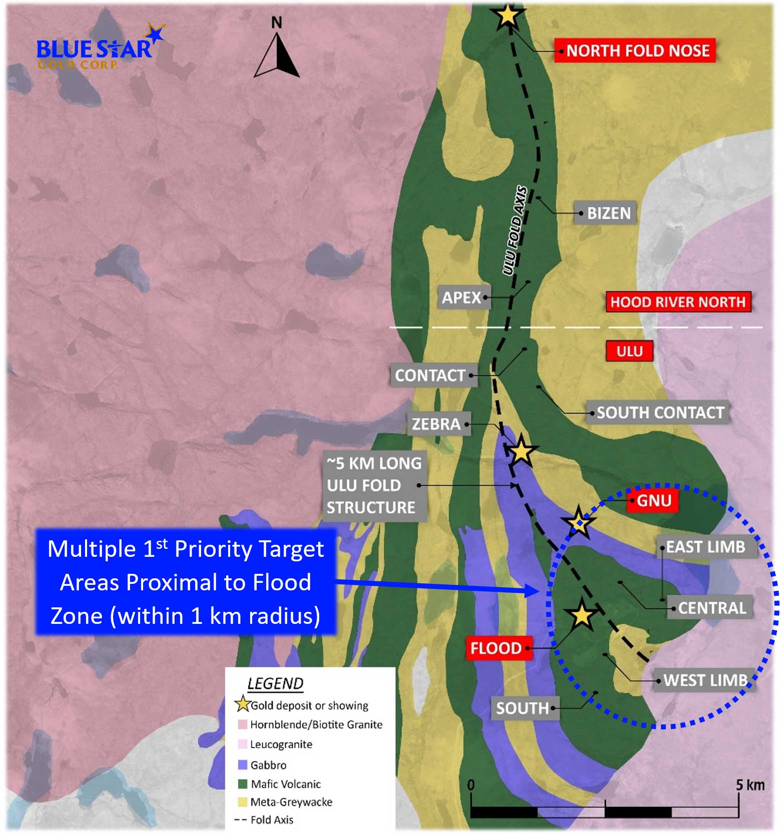
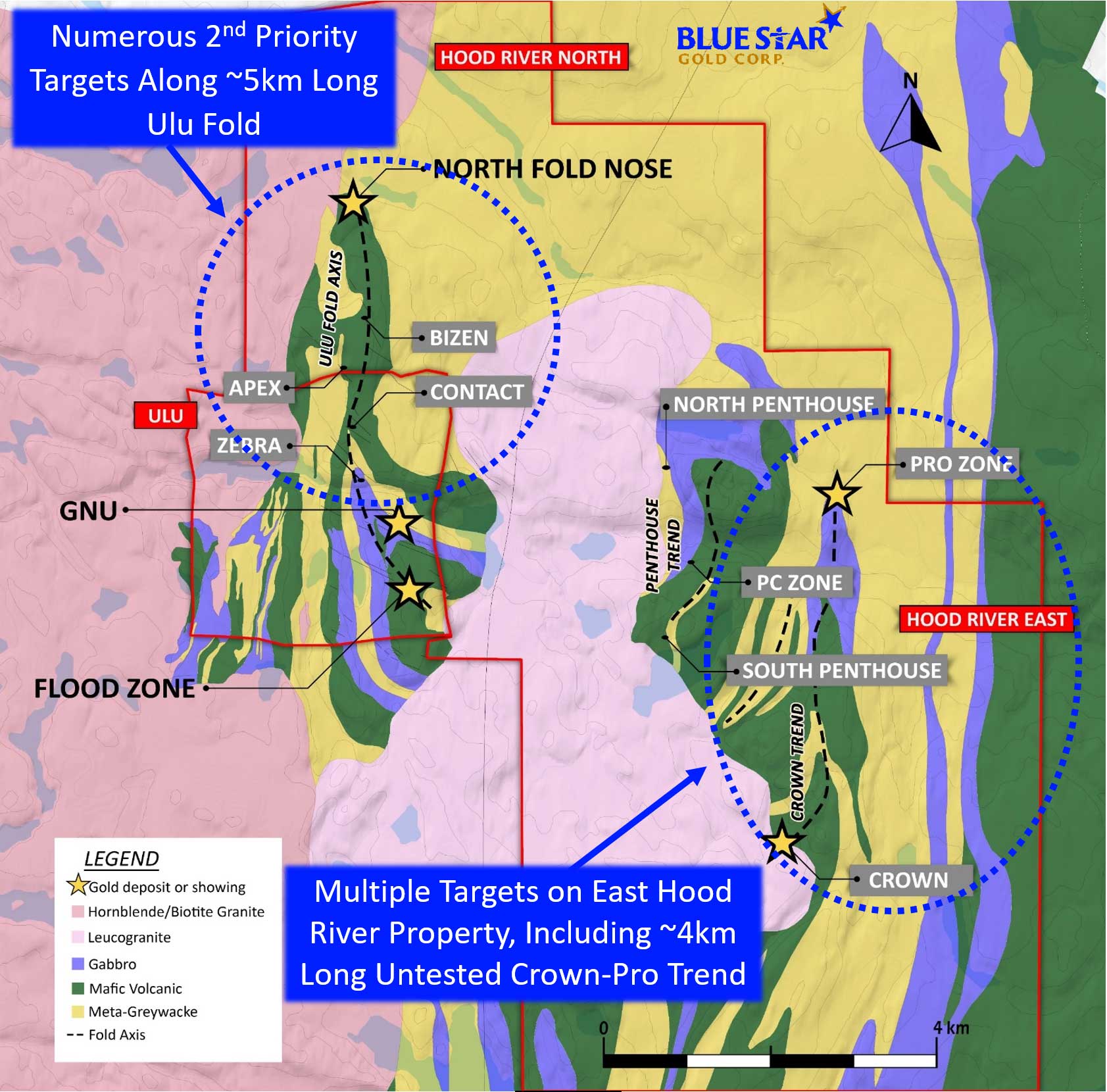
The series of the gold showings and prospects that occur on trend and north of the Flood Zone are considered to be related to the ~5 km long Ulu Fold which hosts the Flood Zone and extends to the NFN Zone. At least five gold prospects have been identified to date on this key structural feature.
11,200 ha exploration concession
Underexplored, high potential for new discovery
Numerous gold drill targets identified for future resource growth
Promise of property stems from the fact it shares the same deformation history (including tight folding) and the same volcano-sedimentary stratigraphic sequence as the Flood Zone (Ulu anticline)
One of the priority target areas is the Crown-Pro Trend, a ~4 km long prospective trace of a north trending fold axis, which links the Crown showing to the Pro Zone. Very limited drilling has occurred is this area, where gold grades up to 15 grams have been sampled
2024 Exploration Program Summary
Blue Star mobilized its 2024 exploration program in May and completed the program in September. The program focused on the Company’s Ulu Gold Project and Roma Project in the Kitikmeot region of Nunavut.
Highlights:
- Mobilization of the discovery drill program at Ulu and Roma Projects occurred in May
- Gold focus, with a component of the program dedicated to discovery of critical mineral depositss
- Priority targets were drilled based on potential for discovery, scale, and proximity to existing resources, including:
- Evaluation of higher-grade, larger targets within and near the Flood deposit
- Initial drill test of the 2023 Mikigon surface discovery, a new style of mineralization at Ulu
- Testing mineralized structures and targets in the trend that hosts the Gnu deposit
- Other high-potential targets were evaluated (both gold and critical minerals)
- 16 diamond drill holes for ~4,000 metres across five main target areas were completed, including: HI (Ataani), Mikigon, Penthouse, Gnu Zone (Nutaaq), and the Flood Zone
- Highlights from the Ulu Gold Project drilling:66 g/t gold
- Targeted Flood Zone structure returned 3.66 metres of 8.46 g/t Au including 1.00 metre of 15.25 g/t Au
- Extended Flood Zone with drillhole intercepts of 9.61 metres of 1.83 g/t Au including 1.36 metres of 3.66 g/t Au, and 3.22 metres of 7.52 g/t Au including 2.01
- Mikigon drilling indicated a pathfinder halo for the system that includes 1+ g/t Au intervals associated with quartz veining, arsenopyrite and elevated bismuth and tellurium values
- Results from drill holes testing both the Nutaaq veins and the inaugural test of the Zebra prospect include:y
- Nutaaq veins returned 17.3 metres of 2.60 g/t Au including 1.0 metre of 23.5 g/t Au, and 6.6 metres of 2.63 g/t Au
- Prospecting samples from the Nutaaq trend returned 23.0, 8.96, 6.03, and 2.49 g/t Au
- Prospecting samples from the Zebra prospect returned grades of 28.1, 14.6, and 5.01 g/t Au
- Inaugural drilling of the Zebra prospect returned encouraging results of 3.6 metres of 1.73 g/t Au including 2.9 metres grading 2.01 g/t Au
The 2023 Exploration Program
The 2023 exploration program at the Hood River Property continued to build and assess its extensive target pipeline with a focus on expanding the current resource areas and prioritising several new targets.
Highlights:
- NEW discovery ”Mikigon Prospect” is a sediment hosted mineralised structure traced for 550 metres into overburden (open), highlighted by samples returning 47.1 grams per tonne (“g/t”) gold, 29.6 g/t gold, and 22.7 g/t gold
- Pipeline target Penthouse confirmed to be a precious metals rich base metal prospect, traced on strike for 400 metres (open), highlighted by samples returning 26.9 g/t gold, 184 g/t silver, 5.73% copper, 7.12% zinc; and 1.54 g/t gold, 8.59 g/t silver, 0.345% copper with 6,850 g/t cobalt
- Pipeline target Rhonda confirmed to be a precious metals rich base metal prospect, at a flexure in a mafic volcanic over sediment contact zone, highlighted by samples returning 6.04 g/t gold, 69.9 g/t silver, 0.587% copper, and 12.4% zinc
- New showings identified north of the North Fold Nose (NFN) resource area returned 5.50 g/t and 3.03 g/t gold from quartz vein samples, and 8.78 g/t gold from sulphide pod in deformed sedimentary rocks; and
- Blackridge Target: samples returning values of 3.51 g/t and 2.08 g/t gold
Discussion of Field Results
Hood River North Targets
Mikigon: this prospect was identified during mapping and prospecting of the sedimentary rocks surrounding the Ulu Fold in an area of no previously known sampling and is the first known substantial sediment hosted mineralised zone in the Ulu Gold Project. It is located approximately 3.5 km NNE of the Flood Zone gold deposit and 1.8 km SE of the NFN deposit. A total of 33 samples, over a strike length of 550 metres from a mineralised trend measuring 1 to 4 metres wide on surface, have been collected to date. The prospect is highlighted by samples returning 47.1 g/t, 29.6 g/t and 22.7 g/t gold and has a mean gold value of 3.75 g/t from all samples in a range of detection limit to 47.1 g/t gold.
New Showings: new gold and base metal showings (North Showings) were identified north of the NFN resource area where complexly deformed sediments occur in close proximity to belt bounding intrusive bodies. Results from quartz veins in fold hinges and sulphide rich zones in fold hinges within schistose sedimentary rocks returned 3.03 g/t and 9.15 g/t gold. Tabular quartz veins in granodiorite–tonalite returned 1.92 g/t and 5.50 g/t gold. Additional mapping and prospecting are required to better understand these new showings, which will be added to the pipeline target list and appropriately prioritised.
Hood River East Target
Penthouse: this prospect is hosted within a sedimentary rock package located below a basalt contact and is traceable for at least 400 metres. The discontinuous massive sulphide horizon ranges from 0.15 to 0.75 metres wide in the main zone with potential for multiple target horizons in the rock package. Similar alteration has been observed below the main level, and gold bearing quartz veins occur at an oblique angle to the contact. Similar material in the folded equivalent of the same stratigraphy located 300 metres across a small valley was also sampled, returning 3.24 g/t gold, 58 g/t silver, 0.1% copper, 0.2% lead and 12.65% zinc. Highlight grades from 31 samples that were assayed include; 0.2 to 344 g/t silver, 19ppm to 5.73% copper, 5.1ppm to 3.86% lead, and 14.6ppm to 12.65% zinc.
Pump Lake: detailed mapping and an initial lithogeochemical survey was completed in this complexly folded stratigraphy that is similar to the Ulu Fold. Limited sampling returned 1.68 g/t gold. Preliminary lithogeochemical results indicate the potential presence of mafic volcanic units similar to those that occur in the core of the Ulu Fold.
Thunder Break: grab samples were collected as part of the initial mapping of this regional structure which separates the Central Domain from the Eastern Domain of the High Lake Belt. No significant results were returned from the limited campaign, but systematic prospecting is warranted along the +10-kilometre-long section of the structure within the Blue Star land package.
Hood River South Targets
The Rhonda Prospect was evaluated to confirm location of historical sampling and better define the north-south contact/structural trend. The core of the prospect is approximately 30 metres long within a 450-metre section of the structure defined by historical soil samples. The prospect is located approximately 1.3 km SW of the Flood Zone gold deposit and 900 metres from the camp road. A total of 15 grab samples were collected from outcrop, subcrop and frost heave returning a mean gold value of 1.97 g/t, a mean silver value of 29.2 g/t and a mean zinc value of 2.8% in a range of detection limit to 6.04 g/t gold, 69.9 g/t silver, and 12.4% zinc.
Blackridge: a parallel trend to the historic Blackridge showing was evaluated this season due to its similar geophysical signature and alteration patterns. Blocky arsenopyrite mineralisation was identified with samples returning values of 3.51 g/t and 2.08 g/t gold.
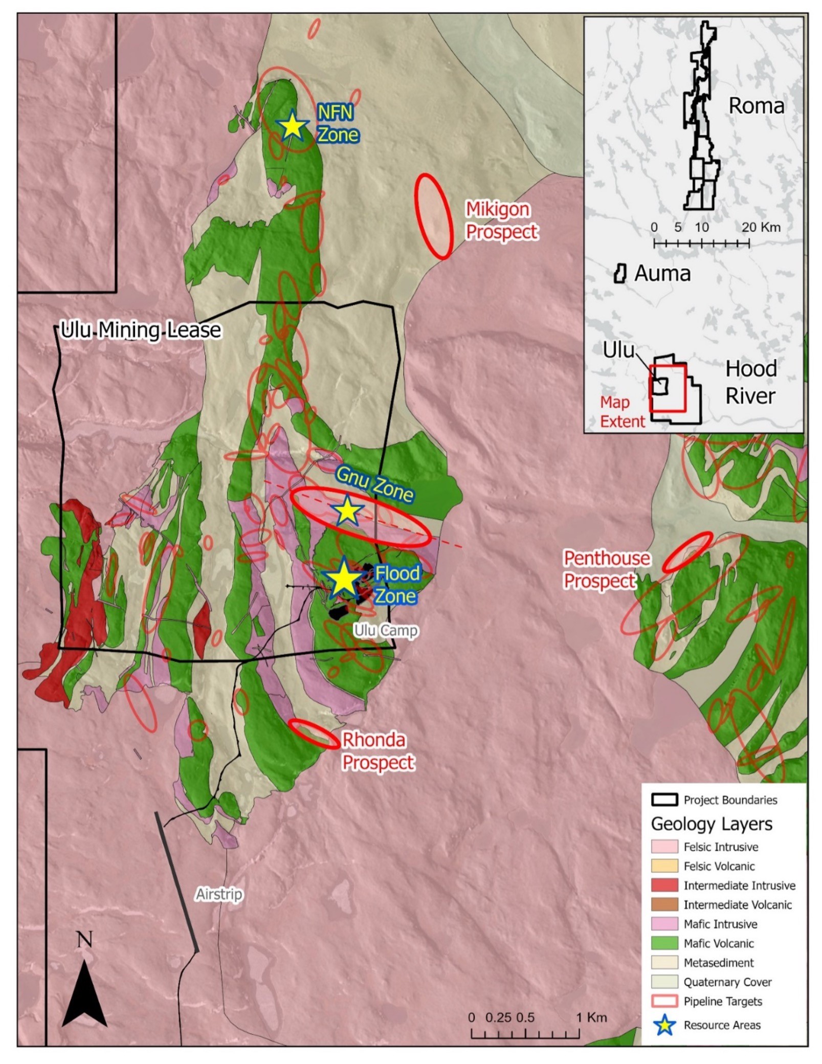
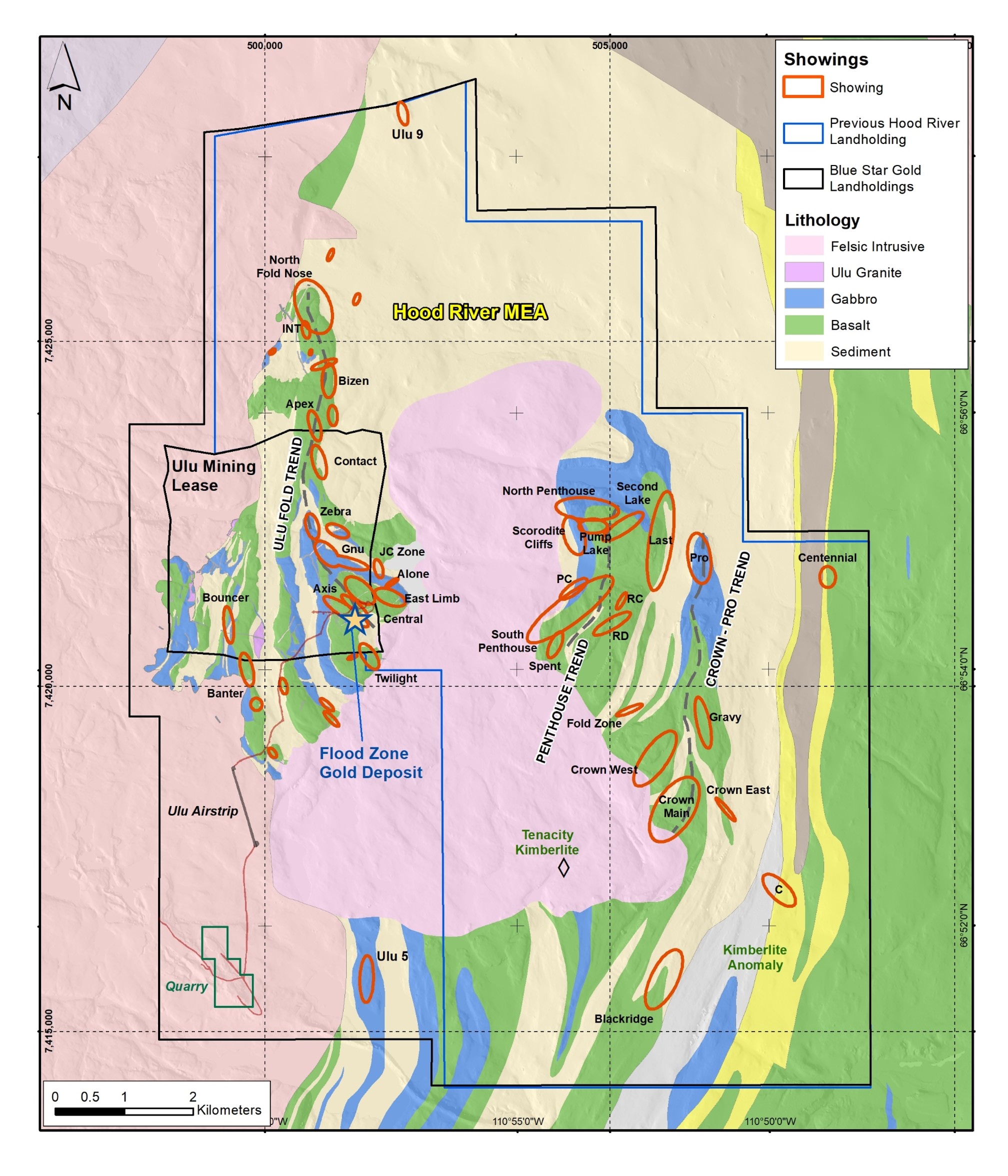
Figure: Ulu-Hood River Target Areas
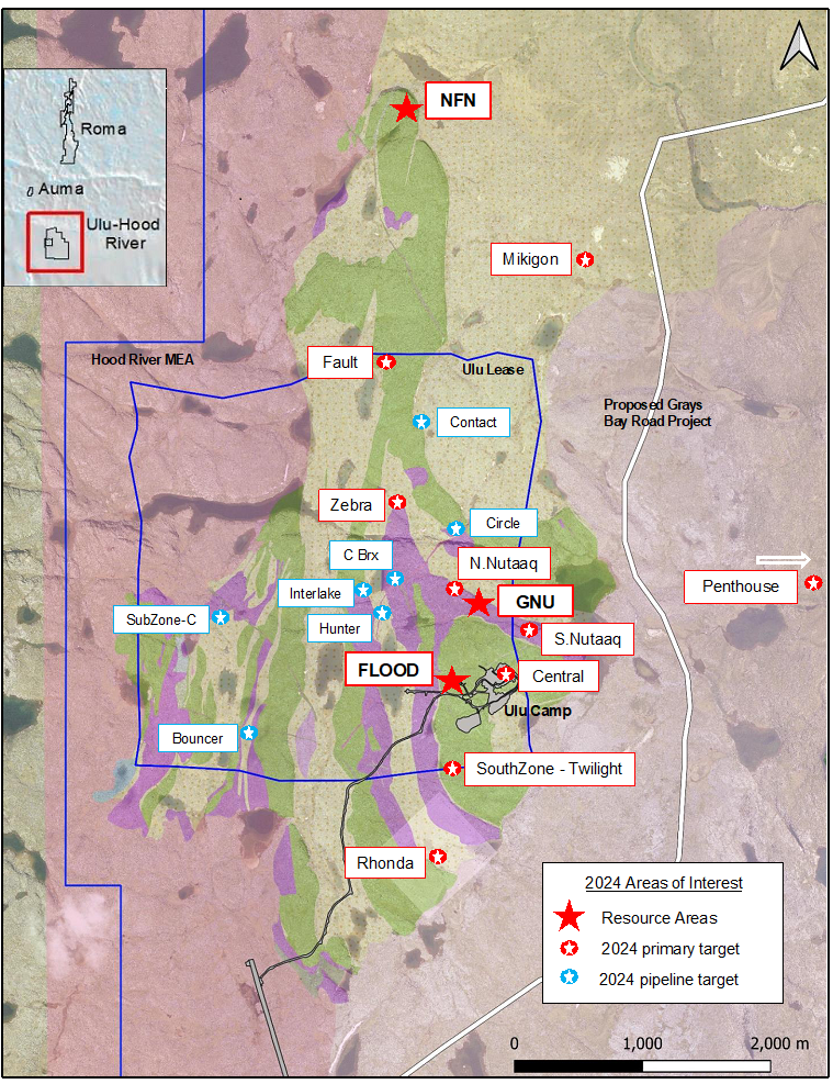
Figure: Ulu-Hood Targets
2022 Exploration Program
Additional regional targeting/testing conducted at the North Penthouse, JC and Gravy target area returned impressive results:
- Check sample of one channel returned 92.40 g/t gold in 2022 at North Penthouse
- JC showing returned samples grading 15.20 g/t gold and 11.05 g/t gold
- Gravy trend (~5,500 metres ESE of Flood Zone deposit): +950-metre-long arsenopyrite rich structural trend returned values that include 8.81 g/t gold and 3.84 g/t gold among numerous multi-gram samples
Generated new targets for future field program
The main deposit, called the Flood Zone, is a northwest-trending, shear hosted anastomosing vein/alteration system that occurs proximal to a basalt-metagreywacke contact at the core of the Ulu Fold. The deposit is steeply dipping to the southwest and has been traced for over 400 metres on surface. The current Flood Zone resource occurs between the surface and a vertical depth of 525 metres. The deepest significant Flood Zone drill intersection assayed 14.9 g/t gold over 7.7 metres at a depth of 610 metres below surface.
In addition to the high-grade Flood Zone gold deposit, the Ulu mining lease hosts several additional prospective target zones, many of which are spatially related to the axis of the ~5 km long Ulu Fold, which extends from the Ulu lease onto the northern part of the Hood River property and culminates at the North Fold Nose Zone.
+20 mineralized showings currently identified on the Hood River Property have been grouped into 5 main zones. A summary of some of the historic exploration results, by zone, is as follows:
North Fold Nose (“NFN”)
The NFN forms the northern extension of the Ulu Anticline, the hosting structure of the best-known part of the Ulu gold deposit, the Flood Zone
A significant section of this structure on the Hood River Property remains untested
Crown Zone (“CZ”)
The CZ is a composite of five individual areas
The larger, “Main Area” was trenched by BHP Billiton whose best-reported trench sample was 24.3 g/t gold over 0.7 metres
Sampling of this site returned 13.47 g/t gold over 2 metres
The Main Area is exposed for 800 metres with widths of up to 6 metres. It remains open to the north
Penthouse South Zone (“PSZ”)
Structurally equivalent to the geological setting of the Ulu gold deposit
At the Penthouse South Zone, a 2-metre-wide shear zone can be traced for over 200 metres. Grab samples from this shear zone grade up to 200 g/t gold
Several quartz veins up to 1 metre wide have been identified at PSZ. Grab samples on these veins have returned assays up to 62 g/t gold
Volcanogenic massive sulphide mineralization has also been identified in areas
Penthouse North Zone (“PNZ”)
At the PNZ, a 0.1 m – 0.5 m wide shear zone can be traced for over 250 metres. Sampling from this area returned up to 130 g/t gold
The Penthouse North and South Zones are located approximately 3 km apart and are separated by a topographically subdued valley with no outcrop
Blackridge Zone (“BRZ”):
A 750-metre-long mineralized vein/shear is exposed at this site
Only limited shallow drilling tested ~300 m of this structure on strike
The best core drill intersection returned 10 g/t gold over 1.07 metres
A 1.0 metre chip sample across this structure returned an assay of 21.58 g/t gold
It is believed there is significant potential to extend the structure to the north
Surface grab samples have returned assays up to 16.8 g/t gold
In February 22, 2023, the Company reported that the independent and qualified person for the Mineral Resource Estimate, as defined by NI 43-101, is Chris MacInnis, P.Geo (#2059) from ALS-GoldSpot Ltd. had completed an independent Technical Report entitled, Technical Report on the Ulu Project, Kitikmeot Region, Nunavut, Canada.
Overview
11,200 ha exploration concession
Underexplored, high potential for new discovery
Numerous gold drill targets identified for future resource growth
Promise of property stems from the fact it shares the same deformation history (including tight folding) and the same volcano-sedimentary stratigraphic sequence as the Flood Zone (Ulu anticline)
One of the priority target areas is the Crown-Pro Trend, a ~4 km long prospective trace of a north trending fold axis, which links the Crown showing to the Pro Zone. Very limited drilling has occurred is this area, where gold grades up to 15 grams have been sampled
Exploration Program
2024 Exploration Program Summary
Blue Star mobilized its 2024 exploration program in May and completed the program in September. The program focused on the Company’s Ulu Gold Project and Roma Project in the Kitikmeot region of Nunavut.
Highlights:
- Mobilization of the discovery drill program at Ulu and Roma Projects occurred in May
- Gold focus, with a component of the program dedicated to discovery of critical mineral depositss
- Priority targets were drilled based on potential for discovery, scale, and proximity to existing resources, including:
- Evaluation of higher-grade, larger targets within and near the Flood deposit
- Initial drill test of the 2023 Mikigon surface discovery, a new style of mineralization at Ulu
- Testing mineralized structures and targets in the trend that hosts the Gnu deposit
- Other high-potential targets were evaluated (both gold and critical minerals)
- 16 diamond drill holes for ~4,000 metres across five main target areas were completed, including: HI (Ataani), Mikigon, Penthouse, Gnu Zone (Nutaaq), and the Flood Zone
- Highlights from the Ulu Gold Project drilling:66 g/t gold
- Targeted Flood Zone structure returned 3.66 metres of 8.46 g/t Au including 1.00 metre of 15.25 g/t Au
- Extended Flood Zone with drillhole intercepts of 9.61 metres of 1.83 g/t Au including 1.36 metres of 3.66 g/t Au, and 3.22 metres of 7.52 g/t Au including 2.01
- Mikigon drilling indicated a pathfinder halo for the system that includes 1+ g/t Au intervals associated with quartz veining, arsenopyrite and elevated bismuth and tellurium values
- Results from drill holes testing both the Nutaaq veins and the inaugural test of the Zebra prospect include:y
- Nutaaq veins returned 17.3 metres of 2.60 g/t Au including 1.0 metre of 23.5 g/t Au, and 6.6 metres of 2.63 g/t Au
- Prospecting samples from the Nutaaq trend returned 23.0, 8.96, 6.03, and 2.49 g/t Au
- Prospecting samples from the Zebra prospect returned grades of 28.1, 14.6, and 5.01 g/t Au
- Inaugural drilling of the Zebra prospect returned encouraging results of 3.6 metres of 1.73 g/t Au including 2.9 metres grading 2.01 g/t Au
The 2023 Exploration Program
The 2023 exploration program at the Hood River Property continued to build and assess its extensive target pipeline with a focus on expanding the current resource areas and prioritising several new targets.
Highlights:
- NEW discovery ”Mikigon Prospect” is a sediment hosted mineralised structure traced for 550 metres into overburden (open), highlighted by samples returning 47.1 grams per tonne (“g/t”) gold, 29.6 g/t gold, and 22.7 g/t gold
- Pipeline target Penthouse confirmed to be a precious metals rich base metal prospect, traced on strike for 400 metres (open), highlighted by samples returning 26.9 g/t gold, 184 g/t silver, 5.73% copper, 7.12% zinc; and 1.54 g/t gold, 8.59 g/t silver, 0.345% copper with 6,850 g/t cobalt
- Pipeline target Rhonda confirmed to be a precious metals rich base metal prospect, at a flexure in a mafic volcanic over sediment contact zone, highlighted by samples returning 6.04 g/t gold, 69.9 g/t silver, 0.587% copper, and 12.4% zinc
- New showings identified north of the North Fold Nose (NFN) resource area returned 5.50 g/t and 3.03 g/t gold from quartz vein samples, and 8.78 g/t gold from sulphide pod in deformed sedimentary rocks; and
- Blackridge Target: samples returning values of 3.51 g/t and 2.08 g/t gold
Discussion of Field Results
Hood River North Targets
Mikigon: this prospect was identified during mapping and prospecting of the sedimentary rocks surrounding the Ulu Fold in an area of no previously known sampling and is the first known substantial sediment hosted mineralised zone in the Ulu Gold Project. It is located approximately 3.5 km NNE of the Flood Zone gold deposit and 1.8 km SE of the NFN deposit. A total of 33 samples, over a strike length of 550 metres from a mineralised trend measuring 1 to 4 metres wide on surface, have been collected to date. The prospect is highlighted by samples returning 47.1 g/t, 29.6 g/t and 22.7 g/t gold and has a mean gold value of 3.75 g/t from all samples in a range of detection limit to 47.1 g/t gold.
New Showings: new gold and base metal showings (North Showings) were identified north of the NFN resource area where complexly deformed sediments occur in close proximity to belt bounding intrusive bodies. Results from quartz veins in fold hinges and sulphide rich zones in fold hinges within schistose sedimentary rocks returned 3.03 g/t and 9.15 g/t gold. Tabular quartz veins in granodiorite–tonalite returned 1.92 g/t and 5.50 g/t gold. Additional mapping and prospecting are required to better understand these new showings, which will be added to the pipeline target list and appropriately prioritised.
Hood River East Target
Penthouse: this prospect is hosted within a sedimentary rock package located below a basalt contact and is traceable for at least 400 metres. The discontinuous massive sulphide horizon ranges from 0.15 to 0.75 metres wide in the main zone with potential for multiple target horizons in the rock package. Similar alteration has been observed below the main level, and gold bearing quartz veins occur at an oblique angle to the contact. Similar material in the folded equivalent of the same stratigraphy located 300 metres across a small valley was also sampled, returning 3.24 g/t gold, 58 g/t silver, 0.1% copper, 0.2% lead and 12.65% zinc. Highlight grades from 31 samples that were assayed include; 0.2 to 344 g/t silver, 19ppm to 5.73% copper, 5.1ppm to 3.86% lead, and 14.6ppm to 12.65% zinc.
Pump Lake: detailed mapping and an initial lithogeochemical survey was completed in this complexly folded stratigraphy that is similar to the Ulu Fold. Limited sampling returned 1.68 g/t gold. Preliminary lithogeochemical results indicate the potential presence of mafic volcanic units similar to those that occur in the core of the Ulu Fold.
Thunder Break: grab samples were collected as part of the initial mapping of this regional structure which separates the Central Domain from the Eastern Domain of the High Lake Belt. No significant results were returned from the limited campaign, but systematic prospecting is warranted along the +10-kilometre-long section of the structure within the Blue Star land package.
Hood River South Targets
The Rhonda Prospect was evaluated to confirm location of historical sampling and better define the north-south contact/structural trend. The core of the prospect is approximately 30 metres long within a 450-metre section of the structure defined by historical soil samples. The prospect is located approximately 1.3 km SW of the Flood Zone gold deposit and 900 metres from the camp road. A total of 15 grab samples were collected from outcrop, subcrop and frost heave returning a mean gold value of 1.97 g/t, a mean silver value of 29.2 g/t and a mean zinc value of 2.8% in a range of detection limit to 6.04 g/t gold, 69.9 g/t silver, and 12.4% zinc.
Blackridge: a parallel trend to the historic Blackridge showing was evaluated this season due to its similar geophysical signature and alteration patterns. Blocky arsenopyrite mineralisation was identified with samples returning values of 3.51 g/t and 2.08 g/t gold.
Figure: Ulu-Hood River Target Areas
Figure: Ulu-Hood Targets
2022 Exploration Program
Additional regional targeting/testing conducted at the North Penthouse, JC and Gravy target area returned impressive results:
- Check sample of one channel returned 92.40 g/t gold in 2022 at North Penthouse
- JC showing returned samples grading 15.20 g/t gold and 11.05 g/t gold
- Gravy trend (~5,500 metres ESE of Flood Zone deposit): +950-metre-long arsenopyrite rich structural trend returned values that include 8.81 g/t gold and 3.84 g/t gold among numerous multi-gram samples
Generated new targets for future field program
Geological Summary
The main deposit, called the Flood Zone, is a northwest-trending, shear hosted anastomosing vein/alteration system that occurs proximal to a basalt-metagreywacke contact at the core of the Ulu Fold. The deposit is steeply dipping to the southwest and has been traced for over 400 metres on surface. The current Flood Zone resource occurs between the surface and a vertical depth of 525 metres. The deepest significant Flood Zone drill intersection assayed 14.9 g/t gold over 7.7 metres at a depth of 610 metres below surface.
In addition to the high-grade Flood Zone gold deposit, the Ulu mining lease hosts several additional prospective target zones, many of which are spatially related to the axis of the ~5 km long Ulu Fold, which extends from the Ulu lease onto the northern part of the Hood River property and culminates at the North Fold Nose Zone.
Exploration Focus
+20 mineralized showings currently identified on the Hood River Property have been grouped into 5 main zones. A summary of some of the historic exploration results, by zone, is as follows:
North Fold Nose (“NFN”)
The NFN forms the northern extension of the Ulu Anticline, the hosting structure of the best-known part of the Ulu gold deposit, the Flood Zone
A significant section of this structure on the Hood River Property remains untested
Crown Zone (“CZ”)
The CZ is a composite of five individual areas
The larger, “Main Area” was trenched by BHP Billiton whose best-reported trench sample was 24.3 g/t gold over 0.7 metres
Sampling of this site returned 13.47 g/t gold over 2 metres
The Main Area is exposed for 800 metres with widths of up to 6 metres. It remains open to the north
Penthouse South Zone (“PSZ”)
Structurally equivalent to the geological setting of the Ulu gold deposit
At the Penthouse South Zone, a 2-metre-wide shear zone can be traced for over 200 metres. Grab samples from this shear zone grade up to 200 g/t gold
Several quartz veins up to 1 metre wide have been identified at PSZ. Grab samples on these veins have returned assays up to 62 g/t gold
Volcanogenic massive sulphide mineralization has also been identified in areas
Penthouse North Zone (“PNZ”)
At the PNZ, a 0.1 m – 0.5 m wide shear zone can be traced for over 250 metres. Sampling from this area returned up to 130 g/t gold
The Penthouse North and South Zones are located approximately 3 km apart and are separated by a topographically subdued valley with no outcrop
Blackridge Zone (“BRZ”):
A 750-metre-long mineralized vein/shear is exposed at this site
Only limited shallow drilling tested ~300 m of this structure on strike
The best core drill intersection returned 10 g/t gold over 1.07 metres
A 1.0 metre chip sample across this structure returned an assay of 21.58 g/t gold
It is believed there is significant potential to extend the structure to the north
Surface grab samples have returned assays up to 16.8 g/t gold
In February 22, 2023, the Company reported that the independent and qualified person for the Mineral Resource Estimate, as defined by NI 43-101, is Chris MacInnis, P.Geo (#2059) from ALS-GoldSpot Ltd. had completed an independent Technical Report entitled, Technical Report on the Ulu Project, Kitikmeot Region, Nunavut, Canada.
Technical Reports
Video Footage